
File:Czechoslovakia 1956–1990.svg

Size of this PNG preview of this SVG file: 450 × 456 pixels. Àteras risolutziones: 237 × 240 pixels | 474 × 480 pixels | 758 × 768 pixels | 1,011 × 1,024 pixels | 2,021 × 2,048 pixels
Versione a risolutzione arta (file in formadu SVG, mannesa nominale 450 × 456 pixel, mannesa de su file: 474 KB)
Ogetu


.svg)
.svg)
.svg)
.svg)
.svg)


.svg)
.svg)
.svg)


.png)
.png)


.svg)


.svg)

.svg)


.svg)
.svg)
.svg)
.svg)


.svg)
.png)


.svg)


.svg)
.svg)


.svg)


.svg)


.svg)
.svg)
.svg)
.svg)
.svg)
.svg)
.svg)
_cropped.svg)
.svg)
.svg)
.svg)
.svg)
.svg)
.svg)
.svg)
.svg)
.svg)
.svg)
.svg)
.svg)
.svg)
.svg)
.svg)
.svg)
.svg)
.svg)
.svg)
.svg)
.svg)
.svg)
.svg)
.svg)
.svg)
.svg)
.svg)
.svg)
.svg)
.svg)
.svg)
.svg)
.svg)
.svg)
.svg)
.svg)
.svg)
.svg)
.svg)
.svg)
.svg)
.svg)
.svg)
.svg)
.svg)
Litzèntzia
Custu documentu est litzentziadu in base a is tèrmines de sa litzèntzia Creative Commons Atributzione-Cumpartzi a sa pròpria manera 3.0 Unported.
- Tue ses lìberu:
- de cundivìder – de copiare, ispainare e trasmìtere s'òpera
- de adatare – de adatare s'òpera
- Suta de sas cunditziones chi sighint:
- atributzione – Depes indicare s'autore comente si tocat, frunire unu ligàmene a sa litzèntzia e indicare si sunt istadas fatas modìficas. Lu podes fàghere in cale si siat manera chi tèngiat sensu, ma no in cale si siat manera chi diat s'idea chi su titulare de sa litzèntzia suportet a tie o a s'impreu tuo.
- cumpartzi a sa pròpria manera – Si modìficas, trasformas, o isvilupas su materiale as a dèpere distribuire sos contributos tuos suta de sa matessi litzèntzia de s'originale o una cumpatìbile.
Original upload log
This image is a derivative work of the following images:
- File:Blank_map_of_Europe.svg licensed with Cc-by-sa-2.5
- 2011-09-19T22:57:58Z Alphathon 680x520 (603759 Bytes) Added North/Northern Cyprus
- 2011-08-23T10:26:48Z Heb 680x520 (604212 Bytes) Added [[:en:Bornholm]] (taken from [[:File:Denmark blank map.svg]])
- 2011-04-12T00:40:40Z Alphathon 680x520 (602549 Bytes) Upgraded Sicily based on "File:Freeworldmaps-sicily.jpg". Upgraded Malta based on "File:Map of Malta 2.png". Simplified Croatian borders.
- 2011-04-10T21:43:04Z Alphathon 680x520 (607359 Bytes) Upgraded Croatia, Bosnia & Herzegovina, Slovenia and surrounding countries based on data from "File:Kroatien - Politische Gliederung (Karte).png"
- 2011-04-10T20:05:09Z Alphathon 680x520 (568373 Bytes) Improved Serbia, Montenegro and surrounding countries using data from "File:Serbia Map.png". Fixed Serbia-Montenegro border. Added Kosovo (using dashed border, since it is not a universally recognised nation, and left the lan
- 2011-04-10T15:55:02Z Alphathon 680x520 (524980 Bytes) Tweaked Ukraine and surrounding countries based on data from "File:Up-map.png"
- 2011-04-10T04:02:09Z Alphathon 680x520 (511168 Bytes) Improved Greece, Albania, F.Y.R. Macedonia and Bulgaria based on "File:Greece topo.jpg"
- 2011-04-10T02:48:52Z Alphathon 680x520 (505569 Bytes) Tweaked Germany and surrounding countries based on info from "File:Germany_general_map.png"
- 2011-04-10T01:54:05Z Alphathon 680x520 (493733 Bytes) Converted all lakes back to separate layer. Added Finish lakes and tweaked Finland shape based on "File:Finland 1996 CIA map.jpg". Added Swiss lakes based on "File:Suisse cantons.svg". Tweaked Scotland and added Lochs.
- 2011-04-10T00:07:54Z Alphathon 680x520 (450120 Bytes) Improved England outline and added Isle of Wight based on "File:England Regions - Blank.svg". Improved Denmark based on "File:2 digit postcode danmark.png". Improved Sweden based on "File:Map of Sweden, CIA, 1996.jpg"
- 2011-04-08T15:53:07Z Alphathon 680x520 (438878 Bytes) Upgraded/fixed various parts of the map. Details: *Some minor fixes to Ireland and added some of the larger lakes based on [[:File:Ireland_trad_counties_named.svg]] *Pretty major fixes to Scotland (mainly the west coast and i
- 2008-09-17T09:50:25Z F7 680x520 (531491 Bytes)
- 2008-09-17T09:42:57Z F7 680x520 (2353 Bytes)
- 2008-05-26T19:04:07Z Collard 680x520 (531491 Bytes) uploading on behalf of [[User:Checkit]], direct complaints to him plox: 'Moved countries out of the "outlines" group, removed "outlines" style class, remove separate style information for Russia'
- 2008-04-30T01:38:52Z TimothyBourke 680x520 (531767 Bytes) Changed the country code of Serbia to RS per [http://en.wikipedia.org/wiki/Serbian_country_codes] and the file [http://www.iso.org/iso/iso3166_en_code_lists.txt].
- 2008-02-08T22:44:37Z CarolSpears 680x520 (531767 Bytes) validated
- 2007-07-10T11:47:59Z MrWeeble 680x520 (533112 Bytes) Updated to include British Crown Dependencies as seperate entities and regroup them as "British Islands", with some simplifications to the XML and CSS
- 2007-05-14T17:17:34Z Zirland 680x520 (540659 Bytes) serbia and montenegro
- 2007-03-30T20:40:49Z W!B: 680x520 (538830 Bytes) minor corr: update nl:Ijsselmeer, del fi:lakes (all small), add ru:lake Oneka (all ref maps.google), glued northern irland back to ie ;)
- 2007-02-05T18:44:32Z Maix 680x520 (538295 Bytes) cropped
- 2007-02-04T15:07:29Z Maix 680x520 (538310 Bytes) {{Information |Description=A blank Map of Europe in SVG format. Every country has an id which is its ISO-3116-1-ALPHA2 code in lower case for easy coloring. |Source=Image based on [[Image:Europe_countries.svg|]] by [[User:Ti
Uploaded with derivativeFX
Istòria de su file
Carca unu grupu data/ora pro castiare su file comente si presentada in su tempus indicadu.
| Data/Ora | Miniatura | Dimensiones | Utente | Cumentu | |
|---|---|---|---|---|---|
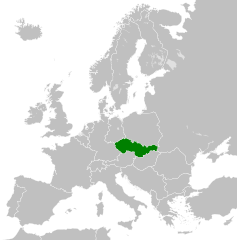
| atuale | 03:41, 30 Stg 2011 | | 450 × 456 (474 KB) | Alphathon | == {{int:filedesc}} == {{Information |Description={{en|Map of en:Czechoslovakia (Czechoslovak Socialist Republic) within Europe}} |Source=*File:Blank_map_of_Europe.svg |Date=2011-10-30 01:38 (UTC) |Author=*File:Blank_map_of_Europe.svg: [[U |
Ligant a custu file
Sa pàgina chi sighit impreat custu documentu:
Impreu globale de su documentu
Impreu de custu documentu in àteras wikis:
- Impreu in als.wikipedia.org
- Impreu in ar.wikipedia.org
- Impreu in azb.wikipedia.org
- Impreu in bg.wikipedia.org
- Impreu in ca.wikipedia.org
- Impreu in ce.wikipedia.org
- Impreu in cs.wikipedia.org
- Impreu in de.wikipedia.org
- Impreu in el.wikipedia.org
- Impreu in en.wikipedia.org
- Impreu in eo.wikipedia.org
- Impreu in es.wikipedia.org
- Impreu in et.wikipedia.org
- Impreu in eu.wikipedia.org
- Impreu in fa.wikipedia.org
- Impreu in fi.wikipedia.org
- Impreu in fr.wikipedia.org
- Impreu in gl.wikipedia.org
- Impreu in he.wikipedia.org
- Impreu in hr.wikipedia.org
- Impreu in id.wikipedia.org
- Impreu in it.wikipedia.org
- Impreu in ja.wikipedia.org
- Impreu in ka.wikipedia.org
- Impreu in ko.wikipedia.org
- Impreu in lv.wikipedia.org
- Impreu in mk.wikipedia.org
- Impreu in ms.wikipedia.org
- Impreu in no.wikipedia.org
- Impreu in pl.wikipedia.org
- Impreu in pnb.wikipedia.org
- Impreu in pt.wikipedia.org
- Impreu in ro.wikipedia.org
- Impreu in ru.wikipedia.org
Càstia àteros impreos globales de custu documentu.