
File:Djerba topographic map-fr.svg

Size of this PNG preview of this SVG file: 666 × 599 pixels. Àteras risolutziones: 267 × 240 pixels | 533 × 480 pixels | 853 × 768 pixels | 1,138 × 1,024 pixels | 2,276 × 2,048 pixels | 1,100 × 990 pixels
Versione a risolutzione arta (file in formadu SVG, mannesa nominale 1,100 × 990 pixel, mannesa de su file: 564 KB)
Ogetu
| Camera location | | View this and other nearby images on: OpenStreetMap |
|---|
| Descritzione |
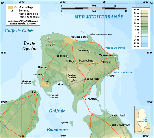
English: Topographic map in French of Djerba Island, Tunisia.
Note: The shaded relief is a raster image embedded in the SVG file. Français : Carte topographique en français de l'île de Djerba, Tunisie.
Note : Les ombres du relief sont une image bitmap embarquée dans le fichier SVG. Norsk bokmål: Topografisk kart over Djerba i Tunisia, på fransk.
UTM projection ; WGS84 datum ; shaded relief (composite image of N-W and N lightning positions) ; |
||
| Data | |||
| Mitza |
Own work ;
|
||
| Autore | Eric Gaba (Sting - fr:Sting) | ||
| Licèntzia (Comente torrare a impreare custu documentu) |
|
||
| Àteras versiones |
Derivative works of this file: []
|


|
This SVG file contains embedded text that can be translated into your language, using any capable SVG editor, text editor or the SVG Translate tool. For more information see: About translating SVG files. |
Litzèntzia
I, the copyright holder of this work, hereby publish it under the following licenses:

|
Est permìtidu copiare, ispainare e/o modificare custu documentu sighende sas cunditziones de sa GNU Free Documentation License, Versione 1.2 o cale si siat versione prus noa publicada dae sa Free Software Foundation; chene peruna setzione fissa, perunu testu de cobertedda e perunu testu de palas. Una còpia de sa litzèntzia est inclùdida in sa setzione titulada GNU Free Documentation License. |
This file is licensed under the Creative Commons Attribution-Share Alike 4.0 International, 3.0 Unported, 2.5 Generic, 2.0 Generic and 1.0 Generic license.
- Tue ses lìberu:
- de cundivìder – de copiare, ispainare e trasmìtere s'òpera
- de adatare – de adatare s'òpera
- Suta de sas cunditziones chi sighint:
- atributzione – Depes indicare s'autore comente si tocat, frunire unu ligàmene a sa litzèntzia e indicare si sunt istadas fatas modìficas. Lu podes fàghere in cale si siat manera chi tèngiat sensu, ma no in cale si siat manera chi diat s'idea chi su titulare de sa litzèntzia suportet a tie o a s'impreu tuo.
- cumpartzi a sa pròpria manera – Si modìficas, trasformas, o isvilupas su materiale as a dèpere distribuire sos contributos tuos suta de sa matessi litzèntzia de s'originale o una cumpatìbile.
Podes seletzionare sa litzèntzia chi boles.
Istòria de su file
Carca unu grupu data/ora pro castiare su file comente si presentada in su tempus indicadu.
| Data/Ora | Miniatura | Dimensiones | Utente | Cumentu | |
|---|---|---|---|---|---|
| atuale | 03:09, 1 Cab 2008 | | 1,100 × 990 (564 KB) | Sting | New standard colors |
| 22:07, 5 Nad 2007 |  | 1,100 × 990 (571 KB) | Sting | Forgotten village name | |
| 12:44, 5 Nad 2007 |  | 1,100 × 990 (571 KB) | Sting | "Ras Rmel" typo correction | |
| 01:11, 5 Nad 2007 |  | 1,100 × 990 (571 KB) | Sting | {{Location|33|45|00|N|10|55|00|E|scale:500000}} <br/> {{Information |Description=Topographic map in French of Djerba Island, Tunisia |Source=Own work ;<br/>Topographic map : [http://www2.jpl.nasa.gov/srtm NASA Shuttle Radar Topography Missi |
Ligant a custu file
Sa pàgina chi sighit impreat custu documentu:
Impreu globale de su documentu
Impreu de custu documentu in àteras wikis:
- Impreu in da.wikipedia.org
- Impreu in en.wikipedia.org
- Impreu in eo.wikipedia.org
- Impreu in fa.wikipedia.org
- Impreu in fr.wikipedia.org
- Impreu in fr.wiktionary.org
- Impreu in gl.wikipedia.org
- Impreu in he.wikipedia.org
- Impreu in incubator.wikimedia.org
- Impreu in it.wikipedia.org
- Impreu in lad.wikipedia.org
- Impreu in pl.wikipedia.org
- Impreu in pt.wikipedia.org
- Impreu in sco.wikipedia.org