
File:Easter Island map-en.svg

Size of this PNG preview of this SVG file: 800 × 569 pixels. Àteras risolutziones: 320 × 228 pixels | 640 × 455 pixels | 1,024 × 729 pixels | 1,280 × 911 pixels | 2,560 × 1,821 pixels | 1,750 × 1,245 pixels
Versione a risolutzione arta (file in formadu SVG, mannesa nominale 1,750 × 1,245 pixel, mannesa de su file: 878 KB)
Ogetu
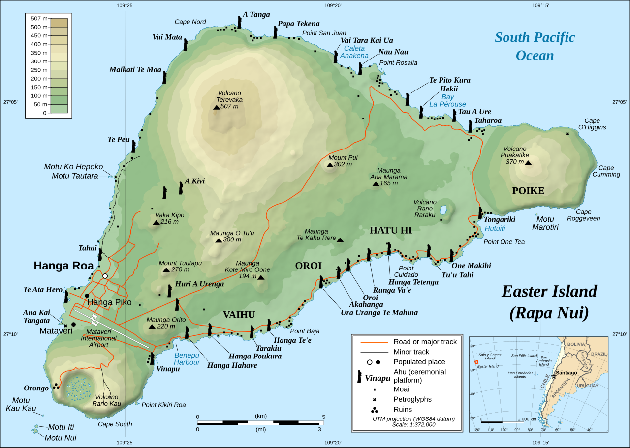
This image was selected as picture of the day on Wikimedia Commons for 1 December 2008. It was captioned as follows: English: Detailed topographic map in English of Easter Island. Other languages:
Afrikaans: Gedetaileerde topografie van Paaseiland Català: Mapa topogràfic detallat en anglès de l'Illa de Pasqua. Čeština: Detailní topografická mapa Velikonočního ostrova Eesti: Detailne inglisekeelne topograafiline kaart et:Lihavõttesaarest. English: Detailed topographic map in English of Easter Island. Esperanto: detala topografia mapo de la Paskinsulo (jen anglalingva, sed ankaŭ havebla en pluraj aliaj lingvoj) Français : Carte topographique détaillée en anglais de l'île de Pâques Italiano: Mappa topografica dell'Isola di Pasqua, Cile. Nederlands: Engelstalige gedetailleerde topografische kaart van Paaseiland Português: Mapa topográfico detalhado, em Inglês, da Ilha da Páscoa Română: Hartă topografică detaliată, în limba engleză, a insulei Paștelui. Svenska: Detaljerad topografisk karta på engelska över Påskön. Македонски: Детална топографска карта на Велигденскиот Остров на англиски. Русский: Топографическая карта Острова Пасхи 한국어: 이스터 섬의 지형도. 中文: 复活节岛地形图 中文(繁體): 復活節島地形圖 |
|

| Descritzione |
English: Detailed topographic map in English of Easter Island
Français : Carte topographique détaillée en anglais de l'île de Paques
Português: Mapa topográfico detalhado, em Inglês, da Ilha da Páscoa.
|
| Data | October 2007 - October 2008 for the new version (see the release note) |
| Mitza |
Own work
|
| Autore | Eric Gaba (Sting), translated by Bamse |
| Licèntzia (Comente torrare a impreare custu documentu) |
Creative Commons: Share Alike – attribution required |
| Àteras versiones |
[]
|


![[1]](http://www.waymarker.co.uk/ml/rapanui/map.jpg)
This W3C-unspecified vector image was created with Inkscape .

|
This SVG file contains embedded text that can be translated into your language, using any capable SVG editor, text editor or the SVG Translate tool. For more information see: About translating SVG files. |
Litzèntzia
I, the copyright holder of this work, hereby publish it under the following license:
Custu documentu est litzentziadu in base a is tèrmines de sa litzèntzia Creative Commons Atributzione-Cumpartzi a sa pròpria manera 2.5 Genèricu.
- Tue ses lìberu:
- de cundivìder – de copiare, ispainare e trasmìtere s'òpera
- de adatare – de adatare s'òpera
- Suta de sas cunditziones chi sighint:
- atributzione – Depes indicare s'autore comente si tocat, frunire unu ligàmene a sa litzèntzia e indicare si sunt istadas fatas modìficas. Lu podes fàghere in cale si siat manera chi tèngiat sensu, ma no in cale si siat manera chi diat s'idea chi su titulare de sa litzèntzia suportet a tie o a s'impreu tuo.
- cumpartzi a sa pròpria manera – Si modìficas, trasformas, o isvilupas su materiale as a dèpere distribuire sos contributos tuos suta de sa matessi litzèntzia de s'originale o una cumpatìbile.
Istòria de su file
Carca unu grupu data/ora pro castiare su file comente si presentada in su tempus indicadu.
| Data/Ora | Miniatura | Dimensiones | Utente | Cumentu | |
|---|---|---|---|---|---|
| atuale | 00:51, 12 Ghe 2023 | | 1,750 × 1,245 (878 KB) | Tseng,Lu-Yen | Reverted to version as of 12:43, 22 October 2008 (UTC) |
| 09:17, 10 Nad 2011 |  | 1,750 × 1,245 (1.92 MB) | Hel-hama | Text appearance improved using Inkscape. | |
| 14:43, 22 Stg 2008 |  | 1,750 × 1,245 (878 KB) | Sting | Completely new version of the map ; new standard colors | |
| 03:06, 30 Stg 2007 |  | 1,750 × 1,245 (536 KB) | Sting | Some additional info | |
| 02:37, 19 Stg 2007 |  | 1,750 × 1,245 (534 KB) | Bamse | ||
| 02:14, 19 Stg 2007 |  | 1,750 × 1,245 (534 KB) | Bamse | {{Information |Description= |Source=self-made |Date= |Author= Bamse }} == Summary == {{Information| |Description=Detailed topographic map in English of Easter island |Source=Own work, translation of Image:Easter Island map-fr.svg<b |
Ligant a custu file
Sa pàgina chi sighit impreat custu documentu:
Impreu globale de su documentu
Impreu de custu documentu in àteras wikis:
- Impreu in af.wikipedia.org
- Impreu in ami.wikipedia.org
- Impreu in ar.wikipedia.org
- Impreu in az.wikipedia.org
- Impreu in bcl.wikipedia.org
- Impreu in bn.wikipedia.org
- Impreu in ca.wikipedia.org
- Impreu in ckb.wikipedia.org
- Impreu in da.wikipedia.org
- Impreu in de.wikipedia.org
- Impreu in el.wikipedia.org
- Impreu in en.wikipedia.org
- Cartography
- Easter Island
- Hanga Roa
- Mu (mythical lost continent)
- Moai
- Motu Nui
- Map coloring
- Rapa Nui National Park
- Hanau epe
- Orongo
- Ahu Tongariki
- Poike
- Rano Kau
- Terevaka
- Ahu Akivi
- List of active separatist movements in Oceania
- User:ISaveNewspapers/sandbox
- Isla de Pascua (commune)
- Portal:Geodesy
- User:Iamojo/testcase/EasterIsland
- Impreu in en.wikiversity.org
- Impreu in en.wikivoyage.org
- Impreu in es.wikipedia.org
- Impreu in et.wikipedia.org
- Impreu in fa.wikipedia.org
- Impreu in frr.wikipedia.org
- Impreu in fr.wikipedia.org
- Impreu in gl.wikipedia.org
Càstia àteros impreos globales de custu documentu.