File:Gibraltar map-en.svg
Page contents not supported in other languages.
Dae Wikipedia, s'entziclopedia lìbera.

Versione a risolutzione arta(file in formadu SVG, mannesa nominale 2,020 × 3,140 pixel, mannesa de su file: 289 KB)

Custu documentu benit dae Wikimedia Commons e podet èssere impreadu in àteros progetos. A sighire est ammustrada sa descritzione in sa sua pàgina de descritzione de su documentu.

Image of the year
Image of the year
Featured image

Wikimedia Commons

This file was a candidate in Picture of the Year 2007.
This is a featured picture on Wikimedia Commons (Featured pictures) and is considered one of the finest images. See its nomination here.

If you have an image of similar quality that can be published under a suitable copyright license, be sure to upload it, tag it, and nominate it.

Ogetu

Camera location36° 08′ 00″ N, 5° 21′ 00″ W Kartographer map based on OpenStreetMap.View this and other nearby images on: OpenStreetMapinfo
Descritzione
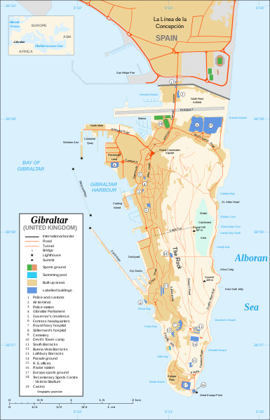
Čeština: Mapa ostrova Gibraltar v angličtině.
English: Map in English of Gibraltar.
Français : * Sujet : Carte en anglais de Gibraltar ;
  • Sources : Création personnelle ;
  • Carte créée à partir de captures d'écran d'images satellite de Google Earth d'un point de vue placé à 1,18 km d'altitude (imagerie disponible de novembre 2007) ;
  • Références complémentaires :
  • Échelle approximative : 1:40 000 (précision : environ 10 m) ;
  • Note : Largeur du tracé des routes proportionnelle à la réalité ;
  • Auteur : Eric Gaba (fr:Sting) ;
  • Date : Novembre 2007.
Português: Mapa (em Inglês) de Gibraltar.
Data
Mitza Own work ;
Map created using screenshots of Google Earth satellite imagery from a point of view located at 1.18 km of altitude (available imagery of November 2007) ;
Other references :
* CIA map ;
* Gibnet map ;
* U.K. MoD map
Locator map : Image:Blank_map_of_South_Europe_and_North_Africa.svg (modified) created by Historicair ;
Approximate scale : 1:40,000 (accuracy : about 10 m)
Note : The roads width is proportional to reality
Autore Eric Gaba (Sting)
Licèntzia
(Comente torrare a impreare custu documentu)
Attribution and Share-Alike required
Àteras versiones

[càmbia]

Disputed isthmus and land
SVG genesis
InfoField
 
The SVG code is valid.
 
This map was created with Inkscape…important.
 
 This map uses embedded text that can be easily translated using a text editor.

Litzèntzia

I, the copyright holder of this work, hereby publish it under the following licenses:
GNU head Est permìtidu copiare, ispainare e/o modificare custu documentu sighende sas cunditziones de sa GNU Free Documentation License, Versione 1.2 o cale si siat versione prus noa publicada dae sa Free Software Foundation; chene peruna setzione fissa, perunu testu de cobertedda e perunu testu de palas. Una còpia de sa litzèntzia est inclùdida in sa setzione titulada GNU Free Documentation License.
w:en:Creative Commons
atributzione cumpartzi a sa pròpria manera
This file is licensed under the Creative Commons Attribution-Share Alike 4.0 International, 3.0 Unported, 2.5 Generic, 2.0 Generic and 1.0 Generic license.
Tue ses lìberu:
  • de cundivìder – de copiare, ispainare e trasmìtere s'òpera
  • de adatare – de adatare s'òpera
Suta de sas cunditziones chi sighint:
  • atributzione – Depes indicare s'autore comente si tocat, frunire unu ligàmene a sa litzèntzia e indicare si sunt istadas fatas modìficas. Lu podes fàghere in cale si siat manera chi tèngiat sensu, ma no in cale si siat manera chi diat s'idea chi su titulare de sa litzèntzia suportet a tie o a s'impreu tuo.
  • cumpartzi a sa pròpria manera – Si modìficas, trasformas, o isvilupas su materiale as a dèpere distribuire sos contributos tuos suta de sa matessi litzèntzia de s'originale o una cumpatìbile.
Podes seletzionare sa litzèntzia chi boles.

Captions

Add a one-line explanation of what this file represents

Items portrayed in this file

depicts inglesu

copyrighted inglesu

36°7'59.999"N, 5°21'0.000"W

MIME type inglesu

image/svg+xml

Istòria de su file

Carca unu grupu data/ora pro castiare su file comente si presentada in su tempus indicadu.

Data/OraMiniaturaDimensionesUtenteCumentu
atuale22:10, 21 Fre 2020Miniatura de sa versione de is 22:10, 21 Fre 20202,020 × 3,140 (289 KB)JoKalliauermalformed svg (compare firefox/chrome rendering with librsvg-rendering) actually firefox/chrome were correct, also it looks wrong
08:01, 29 Làm 2017Miniatura de sa versione de is 08:01, 29 Làm 20172,020 × 3,140 (538 KB)Wereldburger758Removal error in file. Valid SVG now.
23:52, 27 Aus 2008Miniatura de sa versione de is 23:52, 27 Aus 20082,020 × 3,140 (569 KB)RedCoatRemove "claimed by Spain", completely gratuitous for a map
13:28, 11 Nad 2007Miniatura de sa versione de is 13:28, 11 Nad 20072,020 × 3,140 (570 KB)StingNotification of the Spanish claims
16:40, 27 Std 2007Miniatura de sa versione de is 16:40, 27 Std 20072,020 × 3,140 (569 KB)StingAdditional names ; up-to-date corrections
23:35, 26 Std 2007Miniatura de sa versione de is 23:35, 26 Std 20072,020 × 3,140 (561 KB)RedCoatHouse of Assembly → Gibraltar Parliament
21:51, 26 Std 2007Miniatura de sa versione de is 21:51, 26 Std 20072,020 × 3,140 (561 KB)Sting+ info
16:12, 26 Std 2007Miniatura de sa versione de is 16:12, 26 Std 20072,020 × 3,140 (561 KB)Sting+ info
15:21, 26 Std 2007Miniatura de sa versione de is 15:21, 26 Std 20072,020 × 3,140 (561 KB)Sting{{Information |Description=Map in English of Gibraltar |Source=Own work ;<br/>Map created using screenshots of Google Earth satellite imagery from a point of view located at 1.18 km of altitude (available image

Sa pàgina chi sighit impreat custu documentu:

Impreu globale de su documentu

Impreu de custu documentu in àteras wikis:

Metadatos