
File:Lakechad map.png
Lakechad_map.png (588 × 362 pixels, mannesa de su file: 38 KB, tipu de MIME: image/png)
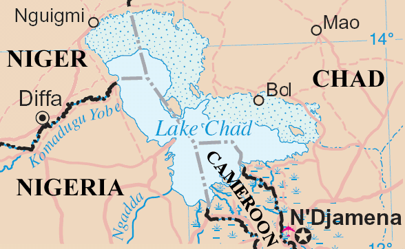
Lake Chad and surrounding area
Map adapted from http://www.un.org/Depts/Cartographic/map/profile/niger.pdf
| This image is a map derived from a United Nations map.
Unless stated otherwise, UN maps are to be considered in the public domain. This applies worldwide. UN maps are, in principle, open source material and you can use them in your work or for making your own map. UN requests however that you delete the UN name, logo and reference number upon any modification to the map. Content of your map will be your responsibility. You can state in your publication, if you wish, something like: based on UN map … (map name, map number, revision number and date). See: Geospatial Information Section. And: Geospatial, location data for a better world. |
 |
Istòria de su file
Carca unu grupu data/ora pro castiare su file comente si presentada in su tempus indicadu.
| Data/Ora | Miniatura | Dimensiones | Utente | Cumentu | |
|---|---|---|---|---|---|
| atuale | 18:20, 23 Maj 2006 | | 588 × 362 (38 KB) | Amcaja | Lake Chad and surrounding area Map adapted from http://www.un.org/Depts/Cartographic/map/profile/niger.pdf {{UN map}} Category:Maps Category:Maps of Cameroon |
Ligant a custu file
Sa pàgina chi sighit impreat custu documentu:
Impreu globale de su documentu
Impreu de custu documentu in àteras wikis:
- Impreu in af.wikipedia.org
- Impreu in an.wikipedia.org
- Impreu in ar.wikipedia.org
- Impreu in bn.wikipedia.org
- Impreu in cy.wikipedia.org
- Impreu in el.wikipedia.org
- Impreu in en.wikipedia.org
- Impreu in es.wikipedia.org
- Impreu in fa.wikipedia.org
- Impreu in fi.wikipedia.org
- Impreu in fr.wikipedia.org
- Impreu in fy.wikipedia.org
- Impreu in he.wikipedia.org
- Impreu in hr.wikipedia.org
- Impreu in id.wikipedia.org
- Impreu in incubator.wikimedia.org
- Impreu in io.wikipedia.org
- Impreu in ja.wikipedia.org
- Impreu in ka.wikipedia.org
- Impreu in kcg.wikipedia.org
- Impreu in ko.wikipedia.org
- Impreu in la.wikipedia.org
- Impreu in lb.wikipedia.org
- Impreu in lt.wikipedia.org
- Impreu in mg.wikipedia.org
- Impreu in mn.wikipedia.org
- Impreu in ms.wikipedia.org
- Impreu in mt.wikipedia.org
- Impreu in my.wikipedia.org
- Impreu in nds-nl.wikipedia.org
- Impreu in nl.wikipedia.org
- Impreu in no.wikipedia.org
- Impreu in oc.wikipedia.org
- Impreu in pa.wikipedia.org
- Impreu in pt.wikipedia.org
- Impreu in qu.wikipedia.org
- Impreu in ro.wikipedia.org
- Impreu in sh.wikipedia.org
- Impreu in simple.wikipedia.org
- Impreu in si.wikipedia.org
- Impreu in sk.wikipedia.org
- Impreu in sl.wikipedia.org
Càstia àteros impreos globales de custu documentu.