
File:Poland 1956-1990.svg

Size of this PNG preview of this SVG file: 450 × 456 pixels. Àteras risolutziones: 237 × 240 pixels | 474 × 480 pixels | 758 × 768 pixels | 1,011 × 1,024 pixels | 2,021 × 2,048 pixels
Versione a risolutzione arta (file in formadu SVG, mannesa nominale 450 × 456 pixel, mannesa de su file: 474 KB)
Ogetu


.svg)
.svg)
.svg)
.svg)
.svg)


.svg)
.svg)
.svg)


.png)
.png)


.svg)


.svg)

.svg)


.svg)
.svg)
.svg)
.svg)


.svg)
.png)


.svg)


.svg)
.svg)


.svg)


.svg)


.svg)
.svg)
.svg)
.svg)
.svg)
.svg)
.svg)
_cropped.svg)
.svg)
.svg)
.svg)
.svg)
.svg)
.svg)
.svg)
.svg)
.svg)
.svg)
.svg)
.svg)
.svg)
.svg)
.svg)
.svg)
.svg)
.svg)
.svg)
.svg)
.svg)
.svg)
.svg)
.svg)
.svg)
.svg)
.svg)
.svg)
.svg)
.svg)
.svg)
.svg)
.svg)
.svg)
.svg)
.svg)
.svg)
.svg)
.svg)
.svg)
.svg)
.svg)
.svg)
.svg)
.svg)
| This is a retouched picture, which means that it has been digitally altered from its original version. The original can be viewed here: Blank map of Europe 1956-1990.svg:
|
Litzèntzia
I, the copyright holder of this work, hereby publish it under the following license:
Custu documentu est litzentziadu in base a is tèrmines de sa litzèntzia Creative Commons Atributzione-Cumpartzi a sa pròpria manera 3.0 Unported.
- Tue ses lìberu:
- de cundivìder – de copiare, ispainare e trasmìtere s'òpera
- de adatare – de adatare s'òpera
- Suta de sas cunditziones chi sighint:
- atributzione – Depes indicare s'autore comente si tocat, frunire unu ligàmene a sa litzèntzia e indicare si sunt istadas fatas modìficas. Lu podes fàghere in cale si siat manera chi tèngiat sensu, ma no in cale si siat manera chi diat s'idea chi su titulare de sa litzèntzia suportet a tie o a s'impreu tuo.
- cumpartzi a sa pròpria manera – Si modìficas, trasformas, o isvilupas su materiale as a dèpere distribuire sos contributos tuos suta de sa matessi litzèntzia de s'originale o una cumpatìbile.
Original upload log
This image is a derivative work of the following images:
- File:Blank_map_of_Europe_1956-1990.svg licensed with Cc-by-sa-3.0
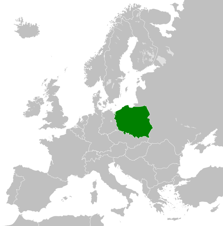
- 2011-10-30T04:43:42Z Alphathon 450x456 (485146 Bytes) == {{int:filedesc}} == {{Information |Description={{en|Blank map of Europe showing national borders as they stood from 1956-1990.}} |Source=*[[:File:Blank_map_of_Europe.svg|]] |Date=2011-10-30 04:42 (UTC) |Author=*[[:File:Bla
Uploaded with derivativeFX
Istòria de su file
Carca unu grupu data/ora pro castiare su file comente si presentada in su tempus indicadu.
| Data/Ora | Miniatura | Dimensiones | Utente | Cumentu | |
|---|---|---|---|---|---|
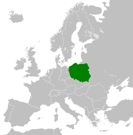
| atuale | 02:23, 26 Std 2011 | | 450 × 456 (474 KB) | StalwartUK | == {{int:filedesc}} == {{Information |Description={{en|Map of the People's Republic of Poland as it was from 1945-1990. Surrounding countries accurate from 1956-1990.}} |Source=*[[:File:Blank_map_of_Europe_1956-1990.svg |
Ligant a custu file
Sa pàgina chi sighit impreat custu documentu:
Impreu globale de su documentu
Impreu de custu documentu in àteras wikis:
- Impreu in an.wikipedia.org
- Impreu in ar.wikipedia.org
- Impreu in az.wikipedia.org
- Impreu in ca.wikipedia.org
- Impreu in cs.wikipedia.org
- Impreu in de.wikipedia.org
- Impreu in el.wikipedia.org
- Impreu in en.wikipedia.org
- Impreu in en.wiktionary.org
- Impreu in eo.wikipedia.org
- Impreu in es.wikipedia.org
- Impreu in et.wikipedia.org
- Impreu in eu.wikipedia.org
- Impreu in fa.wikipedia.org
- Impreu in fi.wikipedia.org
- Impreu in fr.wikipedia.org
- Impreu in gl.wikipedia.org
- Impreu in he.wikipedia.org
- Impreu in hi.wikipedia.org
- Impreu in hu.wikipedia.org
- Impreu in hy.wikipedia.org
- Impreu in id.wikipedia.org
- Impreu in it.wikipedia.org
- Impreu in ja.wikipedia.org
- Impreu in kk.wikipedia.org
- Impreu in ko.wikipedia.org
- Impreu in lt.wikipedia.org
- Impreu in lv.wikipedia.org
- Impreu in mk.wikipedia.org
- Impreu in ms.wikipedia.org
- Impreu in nl.wikipedia.org
- Impreu in pl.wikipedia.org
- Rzeczpospolita Polska
- Polska Rzeczpospolita Ludowa
- Wikipedysta:KrakovHD/brudnopis
- Wikipedysta:OlafMaj1/brudnopi4
- Wikipedysta:TheTNT1500/Lista państw komunistycznych
- Wikipedysta:Malarz pl/szablony/Państwo infobox/4
- Wikipedysta:Malarz pl/szablony/Państwo infobox
- Wikipedysta:Malarz pl/szablony/Państwo infobox/26
- Impreu in pnb.wikipedia.org
- Impreu in pt.wikipedia.org
- Impreu in ro.wikipedia.org
Càstia àteros impreos globales de custu documentu.