
File:Saint-Martin Island map-fr.svg

Size of this PNG preview of this SVG file: 796 × 600 pixels. Àteras risolutziones: 319 × 240 pixels | 637 × 480 pixels | 1,020 × 768 pixels | 1,280 × 964 pixels | 2,560 × 1,928 pixels | 1,102 × 830 pixels
Versione a risolutzione arta (file in formadu SVG, mannesa nominale 1,102 × 830 pixel, mannesa de su file: 867 KB)
Ogetu
| Camera location | | View this and other nearby images on: OpenStreetMap |
|---|
| Descritzione |
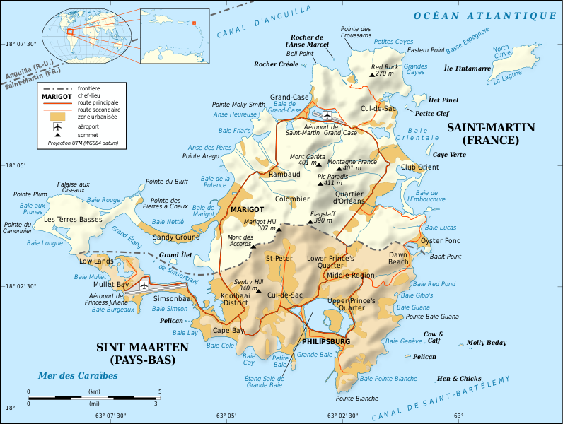
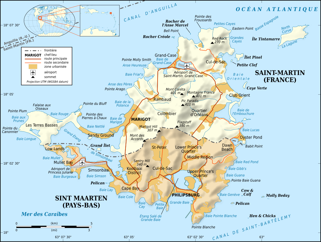
English: Map in French of the Caribbean island of Saint-Martin / Sint Maarten, divided between French and Dutch halves.
Note: the shaded relief is a raster image embedded in the SVG file. Français : Carte en français de l'île de Saint-Martin / Sint Maarten dans les Antilles, divisée en une partie française et une partie néerlandaise. Note : les ombres du relief sont une image bitmap embarquée dans le fichier SVG.
|
||
| Data | |||
| Mitza |
Own work
|
||
| Autore | Eric Gaba (Sting - fr:Sting) | ||
| Licèntzia (Comente torrare a impreare custu documentu) |
|
||
| Àteras versiones |
[]
Same base map but smaller and without topography:
|


|
This SVG file contains embedded text that can be translated into your language, using any capable SVG editor, text editor or the SVG Translate tool. For more information see: About translating SVG files. |
Litzèntzia
I, the copyright holder of this work, hereby publish it under the following licenses:

|
Est permìtidu copiare, ispainare e/o modificare custu documentu sighende sas cunditziones de sa GNU Free Documentation License, Versione 1.2 o cale si siat versione prus noa publicada dae sa Free Software Foundation; chene peruna setzione fissa, perunu testu de cobertedda e perunu testu de palas. Una còpia de sa litzèntzia est inclùdida in sa setzione titulada GNU Free Documentation License. |
This file is licensed under the Creative Commons Attribution-Share Alike 4.0 International, 3.0 Unported, 2.5 Generic, 2.0 Generic and 1.0 Generic license.
- Tue ses lìberu:
- de cundivìder – de copiare, ispainare e trasmìtere s'òpera
- de adatare – de adatare s'òpera
- Suta de sas cunditziones chi sighint:
- atributzione – Depes indicare s'autore comente si tocat, frunire unu ligàmene a sa litzèntzia e indicare si sunt istadas fatas modìficas. Lu podes fàghere in cale si siat manera chi tèngiat sensu, ma no in cale si siat manera chi diat s'idea chi su titulare de sa litzèntzia suportet a tie o a s'impreu tuo.
- cumpartzi a sa pròpria manera – Si modìficas, trasformas, o isvilupas su materiale as a dèpere distribuire sos contributos tuos suta de sa matessi litzèntzia de s'originale o una cumpatìbile.
Podes seletzionare sa litzèntzia chi boles.
Istòria de su file
Carca unu grupu data/ora pro castiare su file comente si presentada in su tempus indicadu.
| Data/Ora | Miniatura | Dimensiones | Utente | Cumentu | |
|---|---|---|---|---|---|
| atuale | 19:58, 16 Abr 2009 | | 1,102 × 830 (867 KB) | Sting | Fonts issues correction |
| 05:42, 17 Ghe 2009 |  | 1,102 × 830 (867 KB) | Sting | == Summary == {{Location|18|04|00|N|63|03|30|W|scale:100000}} <br/> {{Information |Description={{en|Map in French of the Caribbean island of Saint-Martin / Sint Maarten, divided between French and Dutch halves.<br/> ''Note: the shaded |
Ligant a custu file
Is 2 pàginas chi sighint impreant custu documentu:
Impreu globale de su documentu
Impreu de custu documentu in àteras wikis:
- Impreu in als.wikipedia.org
- Impreu in ast.wikipedia.org
- Impreu in az.wikipedia.org
- Impreu in br.wikipedia.org
- Impreu in ca.wikipedia.org
- Impreu in da.wikipedia.org
- Impreu in de.wikipedia.org
- Impreu in en.wikipedia.org
- Impreu in eo.wikipedia.org
- Impreu in fi.wikipedia.org
- Impreu in frr.wikipedia.org
- Impreu in fr.wikipedia.org
- Saint-Martin (île)
- Histoire de Saint-Martin
- Île Tintamarre
- Saint-Martin (royaume des Pays-Bas)
- Frontière entre la France et les Pays-Bas
- Projet:Cartographie/Cartes standards/France
- Route nationale 7 (Saint-Martin)
- Îlet Pinel
- Wikipédia:Le saviez-vous ?/Anecdotes proposées/Archivage des discussions/Archives/2016-5
- Impreu in fr.wikinews.org
- Impreu in gl.wikipedia.org
- Impreu in it.wikipedia.org
- Impreu in it.wikivoyage.org
- Impreu in nl.wikipedia.org
- Impreu in pt.wikipedia.org
- Impreu in ru.wikipedia.org
- Impreu in sv.wikipedia.org
- Impreu in to.wikipedia.org
- Impreu in www.wikidata.org