
File:US insular areas-B.png

Versione a risolutzione arta (1,482 × 624 pixels, mannesa de su file: 51 KB, tipu de MIME: image/png)

|
File:US insular areas SVG.svg is a vector version of this file. It should be used in place of this PNG file when not inferior.
File:US insular areas-B.png → File:US insular areas SVG.svg
For more information, see Help:SVG. |
 |
Ogetu
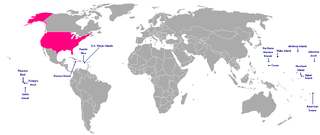
This is a map of the US Insular areas. The first version of this map was based off Image:BlankMap-World-v6.png by User:Astrokey44 with the locations of a few islands added; the source for this are two CIA maps; the maps are a map of the Pacific region and a map of the United States Pacific Island Wildlife Refuges. Hawaii has also been added to the map. Names of the islands are from the CIA Factbook. The second version is based off Image:Dependent_territories_2007.png by User:Sesmith.
For a version color-coded by each islands' status, see Image:US_insular_areas.png. For a version with the freely associated states, see Image:US_insular_areas-B FAS.png.
The previous map is under the GFDL; therefore, this map is too.
Litzèntzia

|
Est permìtidu copiare, ispainare e/o modificare custu documentu sighende sas cunditziones de sa GNU Free Documentation License, Versione 1.2 o cale si siat versione prus noa publicada dae sa Free Software Foundation; chene peruna setzione fissa, perunu testu de cobertedda e perunu testu de palas. Una còpia de sa litzèntzia est inclùdida in sa setzione titulada GNU Free Documentation License. |
| Custu documentu est litzentziadu in base a is tèrmines de sa litzèntzia Creative Commons Atributzione-Cumpartzi a sa pròpria manera 3.0 Unported. | ||
| ||
| This licensing tag was added to this file as part of the GFDL licensing update. |
Istòria de su file
Carca unu grupu data/ora pro castiare su file comente si presentada in su tempus indicadu.
| Data/Ora | Miniatura | Dimensiones | Utente | Cumentu | |
|---|---|---|---|---|---|
| atuale | 13:10, 9 Ghe 2008 | | 1,482 × 624 (51 KB) | Hoshie | rebuilt using User:Sesmith's maps; more to come. |
| 12:43, 17 Mar 2007 |  | 1,482 × 624 (32 KB) | Hoshie | This is a map of the US Insular areas. The base map is Image:BlankMap-World-v6.png by User:Astrokey44 with the locations of a few islands added; the source for this are two CIA maps; the maps are a [https://www.cia.gov/cia/publications/factbook/r |
Ligant a custu file
Peruna pàgina ligat a custu file.
Impreu globale de su documentu
Impreu de custu documentu in àteras wikis:
- Impreu in en.wikipedia.org
- Impreu in kk.wikipedia.org