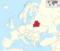
File:Belarus in Europe.svg

Page contents not supported in other languages.
Dae Wikipedia, s'entziclopedia lìbera.

Versione a risolutzione arta(file in formadu SVG, mannesa nominale 1,401 × 1,198 pixel, mannesa de su file: 2.61 MB)

Custu documentu benit dae Wikimedia Commons e podet èssere impreadu in àteros progetos. A sighire est ammustrada sa descritzione in sa sua pàgina de descritzione de su documentu.

Ogetu

Descritzione
Deutsch: Lage von Belarus in Europa.
English: Location of Belarus in Europe.
Data
Mitza Traballu pròpriu
 
This SVG _?_ includes elements from this _?_:
Europe laea location map.svg (by Alexrk2).
 
This SVG _?_ includes elements from this _?_:
BlankMap-World6.svg (by Canuckguy).
 
This SVG _?_ includes elements from this _?_:
Azerbaijan location map.svg (by Uwe Dedering).
 
This SVG _?_ includes elements from this _?_:
Moldova location map.svg (by NordNordWest).
 
This SVG _?_ includes elements from this _?_:
Cyprus location map.svg (by NordNordWest).
 
This SVG _?_ includes elements from this _?_:
Georgia location map.svg (by NordNordWest).
Autore TUBS Gallery
Àteras versiones

This SVG map is part of a locator map series applying the widespread location map scheme. Please see root category to browse for more.

SVG genesis
InfoField
 
The SVG code is valid.
 
This map was created with Adobe Illustrator,
 
and with Inkscape.
 
This SVG map was uploaded with Commonist.

Litzèntzia

I, the copyright holder of this work, hereby publish it under the following license:
w:en:Creative Commons
atributzione cumpartzi a sa pròpria manera
Custu documentu est litzentziadu in base a is tèrmines de sa litzèntzia Creative Commons Atributzione-Cumpartzi a sa pròpria manera 3.0 Unported.
Tue ses lìberu:
  • de cundivìder – de copiare, ispainare e trasmìtere s'òpera
  • de adatare – de adatare s'òpera
Suta de sas cunditziones chi sighint:
  • atributzione – Depes indicare s'autore comente si tocat, frunire unu ligàmene a sa litzèntzia e indicare si sunt istadas fatas modìficas. Lu podes fàghere in cale si siat manera chi tèngiat sensu, ma no in cale si siat manera chi diat s'idea chi su titulare de sa litzèntzia suportet a tie o a s'impreu tuo.
  • cumpartzi a sa pròpria manera – Si modìficas, trasformas, o isvilupas su materiale as a dèpere distribuire sos contributos tuos suta de sa matessi litzèntzia de s'originale o una cumpatìbile.
I'd greatly appreciate, that you attribute this media file to Wikimedia Commons, if used outside Wikipedia or Commons. For use in publications such as books, newspapers, blogs, websites, please insert here the following line:
{{published|author= |date= |url= |title= |org= }}
and fill the applicable fields. (Example). License terms given above still apply.

বাংলা  Deutsch  Deutsch (Sie-Form)  Ελληνικά  English  español  français  Ἀρχαία ἑλληνικὴ  Bahasa Indonesia  日本語  македонски  Nederlands  português  русский  Türkçe  简体中文  繁體中文  +/−

Captions

Add a one-line explanation of what this file represents
Location of Belarus in Europe

Items portrayed in this file

depicts inglesu

copyrighted inglesu

media type inglesu

image/svg+xml

checksum inglesu

9696d62171cc61afb9a9d34f3650827b37a6ac4e

determination method inglesu: SHA-1 inglesu

data size inglesu

2,739,468 byte

height inglesu

1,198 pixel

width inglesu

1,401 pixel

Istòria de su file

Carca unu grupu data/ora pro castiare su file comente si presentada in su tempus indicadu.

Data/OraMiniaturaDimensionesUtenteCumentu
atuale05:56, 12 Trì 2016Miniatura de sa versione de is 05:56, 12 Trì 20161,401 × 1,198 (2.61 MB)Stasyan117Dotted line between Ukraine and Crimea
16:05, 17 Mar 2011Miniatura de sa versione de is 16:05, 17 Mar 20111,401 × 1,198 (4.04 MB)TUBS

Peruna pàgina ligat a custu file.

Impreu globale de su documentu

Impreu de custu documentu in àteras wikis:

Metadatos