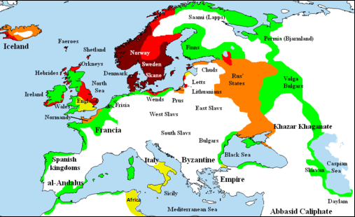
File:Viking expansion.png

Page contents not supported in other languages.
Dae Wikipedia, s'entziclopedia lìbera.

Viking_expansion.png(507 × 310 pixels, mannesa de su file: 109 KB, tipu de MIME: image/png)

Custu documentu benit dae Wikimedia Commons e podet èssere impreadu in àteros progetos. A sighire est ammustrada sa descritzione in sa sua pàgina de descritzione de su documentu.

(see en:File talk:Viking Expansion.svg)

Ogetu

Descritzione
English: Map showing area of Scandinavian settlement (Vikings and Normans descendants from Normandy) in
 
eighth century
 
ninth century
 
tenth century
 
eleventh century
 
denotes areas subjected to frequent Scandinavian contacts, but with little or no Scandinavian settlement
Data 14 Santandria 2006 (original upload date)
Mitza Briangotts (original uploader)
Autore Briangotts (original uploader)
Licèntzia
(Comente torrare a impreare custu documentu)
I, the copyright holder of this work, hereby publish it under the following licenses:
GNU head Est permìtidu copiare, ispainare e/o modificare custu documentu sighende sas cunditziones de sa GNU Free Documentation License, Versione 1.2 o cale si siat versione prus noa publicada dae sa Free Software Foundation; chene peruna setzione fissa, perunu testu de cobertedda e perunu testu de palas. Una còpia de sa litzèntzia est inclùdida in sa setzione titulada GNU Free Documentation License.
w:en:Creative Commons
atributzione cumpartzi a sa pròpria manera
Custu documentu est litzentziadu in base a is tèrmines de sa litzèntzia Creative Commons Atributzione-Cumpartzi a sa pròpria manera 3.0 Unported.
Tue ses lìberu:
  • de cundivìder – de copiare, ispainare e trasmìtere s'òpera
  • de adatare – de adatare s'òpera
Suta de sas cunditziones chi sighint:
  • atributzione – Depes indicare s'autore comente si tocat, frunire unu ligàmene a sa litzèntzia e indicare si sunt istadas fatas modìficas. Lu podes fàghere in cale si siat manera chi tèngiat sensu, ma no in cale si siat manera chi diat s'idea chi su titulare de sa litzèntzia suportet a tie o a s'impreu tuo.
  • cumpartzi a sa pròpria manera – Si modìficas, trasformas, o isvilupas su materiale as a dèpere distribuire sos contributos tuos suta de sa matessi litzèntzia de s'originale o una cumpatìbile.
This licensing tag was added to this file as part of the GFDL licensing update.
Podes seletzionare sa litzèntzia chi boles.
Àteras versiones

[càmbia]

File:Viking Expansion.svg is a vector version of this file. It should be used in place of this PNG file when not inferior.

File:Viking expansion.png → File:Viking Expansion.svg

For more information, see Help:SVG.

In other languages
Alemannisch  Bahasa Indonesia  Bahasa Melayu  British English  català  čeština  dansk  Deutsch  eesti  English  español  Esperanto  euskara  français  Frysk  galego  hrvatski  Ido  italiano  lietuvių  magyar  Nederlands  norsk bokmål  norsk nynorsk  occitan  Plattdüütsch  polski  português  português do Brasil  română  Scots  sicilianu  slovenčina  slovenščina  suomi  svenska  Tiếng Việt  Türkçe  vèneto  Ελληνικά  беларуская (тарашкевіца)  български  македонски  нохчийн  русский  српски / srpski  татарча/tatarça  українська  ქართული  հայերեն  বাংলা  தமிழ்  മലയാളം  ไทย  한국어  日本語  简体中文  繁體中文  עברית  العربية  فارسی  +/−
New SVG image

Captions

Add a one-line explanation of what this file represents

Items portrayed in this file

depicts inglesu

copyrighted inglesu

media type inglesu

image/png

Istòria de su file

Carca unu grupu data/ora pro castiare su file comente si presentada in su tempus indicadu.

(ùrtima | prima) Càstia (10 prus nous | ) (10 | 20 | 50 | 100 | 250 | 500).
Data/OraMiniaturaDimensionesUtenteCumentu
atuale00:58, 26 Fre 2018Miniatura de sa versione de is 00:58, 26 Fre 2018507 × 310 (109 KB)AsmodimAdded the territory of the Norman "Kingdom of Africa (see the wikipedia article), conquests of the Norman kingdom of Sicily under Roger II
20:10, 5 Aus 2016Miniatura de sa versione de is 20:10, 5 Aus 2016507 × 310 (109 KB)TheutatisExpanded area in Italy according to Norman expansion.
12:52, 17 Trì 2008Miniatura de sa versione de is 12:52, 17 Trì 2008800 × 310 (140 KB)F7~commonswiki
23:14, 15 Maj 2007Miniatura de sa versione de is 23:14, 15 Maj 20071,464 × 568 (51 KB)Briangotts== Summary == {{Information |Description= Map showing area of Scandinavian settlement in<br> {{legend|#800000|eighth centuries}} {{legend|#f00|ninth centuries}} {{legend|#ff8000|tenth centuries}} {{legend|#eded00|eleventh centuries}} {{legend|#0f0|denotes
15:58, 10 Maj 2007Miniatura de sa versione de is 15:58, 10 Maj 20071,464 × 568 (51 KB)Briangotts== Summary == {{Information |Description= Map showing area of Scandinavian settlement in<br> {{legend|#800000|eighth century}} {{legend|#f00|ninth century}} {{legend|#ff8000|tenth century}} {{legend|#eded00|eleventh century}} {{legend|#0f0|denotes areas s
21:56, 16 Abr 2007Miniatura de sa versione de is 21:56, 16 Abr 20071,464 × 568 (33 KB)Tene~commonswikiOptimised (0)
13:43, 23 Fre 2007Miniatura de sa versione de is 13:43, 23 Fre 20071,464 × 568 (79 KB)Dbachmann"yellow"
13:33, 23 Fre 2007Miniatura de sa versione de is 13:33, 23 Fre 20071,464 × 568 (80 KB)Dbachmanncropped, fiddled with Iceland.
20:58, 2 Fre 2007Miniatura de sa versione de is 20:58, 2 Fre 20071,838 × 710 (62 KB)Tene~commonswikiOptimised (0)
14:50, 20 Ghe 2007Miniatura de sa versione de is 14:50, 20 Ghe 20071,838 × 710 (110 KB)Liftarn{{Information |Description=Map showing area of Scandinavian settlement in the eighth (dark red), ninth (red), tenth (orange) and eleventh (yellow) centuries. Green denotes areas subjected to frequent en:Viking raids. [[:e
(ùrtima | prima) Càstia (10 prus nous | ) (10 | 20 | 50 | 100 | 250 | 500).

Peruna pàgina ligat a custu file.

Impreu globale de su documentu

Impreu de custu documentu in àteras wikis:

Metadatos