
File:Iron Curtain map.svg

Size of this PNG preview of this SVG file: 560 × 599 pixels. Àteras risolutziones: 224 × 240 pixels | 449 × 480 pixels | 718 × 768 pixels | 957 × 1,024 pixels | 1,914 × 2,048 pixels | 645 × 690 pixels
Versione a risolutzione arta (file in formadu SVG, mannesa nominale 645 × 690 pixel, mannesa de su file: 322 KB)
Ogetu
| Descritzione |
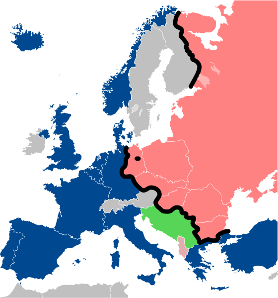
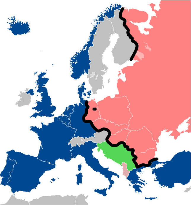
Lëtzebuergesch: Kaart vum Westen an dem Ostblock an Europa während dem Kale Krich.
"Eise Rido"
Neutral Länner
|
||
| Data | |||
| Mitza |
Travail personnel (own work). Sources:
|
||
| Autore | Sémhur | ||
| Àteras versiones |
File:Iron Curtain map alternative.svg (Same, but with Yugoslavia on the Eastern side of the Iron Curtain.) | ||
| Atributzione (required by the license) | © Sémhur / Wikimedia Commons / | ||
| SVG | W3C-validity not checked.
|
||
| Graphic Lab |

| Camera location | | View this and other nearby images on: OpenStreetMap |
|---|
Litzèntzia
I, the copyright holder of this work, hereby publish it under the following licenses:
| Copyleft: This work of art is free; you can redistribute it and/or modify it according to terms of the Free Art License. You will find a specimen of this license on the Copyleft Attitude site as well as on other sites. |
This file is licensed under the Creative Commons Attribution-Share Alike 4.0 International, 3.0 Unported, 2.5 Generic, 2.0 Generic and 1.0 Generic license.
- Tue ses lìberu:
- de cundivìder – de copiare, ispainare e trasmìtere s'òpera
- de adatare – de adatare s'òpera
- Suta de sas cunditziones chi sighint:
- atributzione – Depes indicare s'autore comente si tocat, frunire unu ligàmene a sa litzèntzia e indicare si sunt istadas fatas modìficas. Lu podes fàghere in cale si siat manera chi tèngiat sensu, ma no in cale si siat manera chi diat s'idea chi su titulare de sa litzèntzia suportet a tie o a s'impreu tuo.
- cumpartzi a sa pròpria manera – Si modìficas, trasformas, o isvilupas su materiale as a dèpere distribuire sos contributos tuos suta de sa matessi litzèntzia de s'originale o una cumpatìbile.
Podes seletzionare sa litzèntzia chi boles.
Istòria de su file
Carca unu grupu data/ora pro castiare su file comente si presentada in su tempus indicadu.
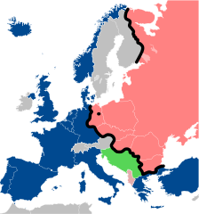
| Data/Ora | Miniatura | Dimensiones | Utente | Cumentu | |
|---|---|---|---|---|---|
| atuale | 15:26, 15 Nad 2022 | | 645 × 690 (322 KB) | PhotographyEdits | Extend the Iron Curtain eastwards of Yugoslavia. Even though Yugoslavia was not really considered part of the West, the currenet map gives the false impression that there was a huge gap in the Iron Curtain, which wasn't the case. |
| 02:56, 23 Trì 2022 |  | 645 × 690 (321 KB) | Kwamikagami | NATO blue, #004990 | |
| 22:30, 30 Mar 2019 |  | 645 × 690 (321 KB) | Sémhur | Reverted to version as of 07:07, 27 May 2014 (UTC). Albania leaves the Waras Pack in middle of cold war; this is why it's shown wtih stripes. | |
| 11:18, 24 Mar 2019 |  | 512 × 548 (123 KB) | Hakuli | Albania leaves the Waras Pack in middle of cold war | |
| 09:07, 27 Maj 2014 |  | 645 × 690 (321 KB) | Sémhur | Valid SVG | |
| 15:51, 16 Std 2010 |  | 645 × 690 (321 KB) | Sémhur | Added Iron Curtain between Bulgaria and Greece & Turkey. | |
| 18:57, 27 Cab 2008 |  | 645 × 690 (321 KB) | Sémhur | Correcting mistake : Austria wasn't in NATO. | |
| 12:51, 31 Maj 2008 |  | 645 × 690 (330 KB) | Sémhur | {{Information |Description={{en|1=Map of the Iron Curtain in Europe.}} {{fr|1=Carte du rideau de fer en Europe.}} {{es|1=Mapa del Telón de Acero en Europa.}} |Source=Travail personnel (ow |
Ligant a custu file
Sa pàgina chi sighit impreat custu documentu:
Impreu globale de su documentu
Impreu de custu documentu in àteras wikis:
- Impreu in af.wikipedia.org
- Impreu in als.wikipedia.org
- Impreu in ar.wikipedia.org
- Impreu in ast.wikipedia.org
- Impreu in azb.wikipedia.org
- Impreu in az.wikipedia.org
- Impreu in ba.wikipedia.org
- Impreu in be-tarask.wikipedia.org
- Impreu in be.wikipedia.org
- Impreu in bg.wikipedia.org
- Impreu in br.wikipedia.org
- Impreu in bs.wikipedia.org
- Impreu in ca.wikipedia.org
- Impreu in cs.wikipedia.org
- Impreu in cy.wikipedia.org
- Impreu in da.wikipedia.org
- Impreu in de.wikipedia.org
- Impreu in el.wikipedia.org
- Impreu in el.wiktionary.org
- Impreu in en.wikipedia.org
- Impreu in en.wikibooks.org
- Impreu in en.wikiquote.org
- Impreu in en.wiktionary.org
Càstia àteros impreos globales de custu documentu.